Would you believe that a group of four Barbadians could get lost in our mere 166 square miles? Well we did, and not once but several times! Here’s our story…
We thought we were well prepared with our list of places to visit, printed island map and several decades of combined experience growing up and living in Barbados. We were wrong.
Meeting last week in the north of Barbados at the border of St.Peter and St.Lucy we got an early start in bright sunshine. We quickly reached our first stop at Shermans, getting out of the cars to snap photos of the lovely Fish Pot restaurant and adjoining beach.
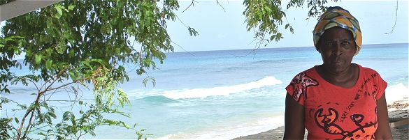
Here we passed a lady selling handmade jewellery who beckoned us over to have a look. Falling into the chatter that comes easily to Bajans she told us she makes it all herself and that she had a pretty good winter season making several sales to visitors. One of us inquired about a ring in rasta colours – red, yellow and green. She didn’t have any at the time but promised to make one just for him and he could stop by for it in a few days. Now that’s unbeatable customer service.
I couldn’t help but notice what a beautiful “office” view she has; it certainly beats my windows and walls.

Her “office view”!
We were feeling pretty pleased as we headed onwards. One stop down and about 3 dozen to go! This is where we literally lost our way. Looking for Freyers Well Bay we followed whatever signs we saw but promptly ended up in a quiet residential cul-de-sac.
But no problem, an elderly homeowner saw us and kindly offered directions. Now you have to understand that Bajan directions are not along the lines of “follow road X until you reach road Y then turn left”. It’s more like “go back that way, when you see a church on the right, make a left turn, then swing back right quick”. Thanking the gentleman, we turned around and “went back that way”!
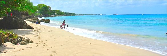
As we drove along carefully looking out for the church, a group of children playing marbles at the side of the road called out “You looking for the beach?”. “Yes” we replied. More directions followed and after a few twists & turns we reached the beautiful secluded beach at Fryers Well. Getting to our second point had taken nearly a half hour but it was worth it.

The beach at Fryers Well Bay
Some more photos and we were off again, waving to the children as we passed and thanking them for their help.
Next stop… Maycocks Bay. We had consulted the map and were confident we’d quickly find this one. Wrong again. Realizing we were once again lost, I asked an old lady walking along the road for directions. It turns out she was nearly deaf but after I shouted “Maycocks Bay” a few times, she kindly advised that the road we were on is now impassable and recommended another route. We thanked her and set off again.
After a few minutes we began wondering if we’d gone wrong once more. Just then a gentleman came to our rescue, letting us know that we were on the correct road and suggesting we park by his home and complete the journey to Maycocks Bay on foot.
We quickly found the bay. Well, not exactly. We could spot the bay down below the cliff we were standing on but had no idea how to reach it. We searched for a trail or track but found nothing. Just as we had resigned ourselves to just taking photos from above, we saw a gardener working at a nearby house. Since we’d been kindly getting directions all morning, we figured we’d try once more.
We got much more than directions; we got a wonderful tour guide. He led us down a fairly steep track to the bay and proudly talked about surfing & fishing spots in the area. He also revealed that he often helps out visitors by guiding them to Maycocks, just as he had done for us. Once back on top the cliff he showed us the spot where he had seen several whales swimming offshore just a few days earlier.

The trail leading to Maycocks Bay
After a cooling drink & tasty snack at a small bakery we were ready to hit the road again. Harrison’s Point Lighthouse was our next destination.

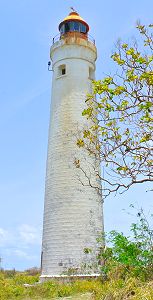
Harrison Point Lighthouse
Feeling smart, I figured why wait until we get lost to ask for directions, why not get them before we leave! The lady working in the bakery explained the route to the lighthouse. I remember hearing a lot of “turn left”. I must have missed one because before we knew it we were seeing the lighthouse in our rear view mirror! Sighing I admitted defeat and once again put the car in reverse. With the additional “left turn” we were on our way through cane fields and along tracks to the lighthouse.
The slight detour did not detract from the destination. Harrison Point Lighthouse, although not open to the public, is truly magnificent. One can only imagine the view from the top. The lighthouse dates back to 1925 and is still in very good condition. I do hope it can be reopened one day.
The view from the clifftop was just as impressive with the waves of the Atlantic Ocean pounding against the clifftops. A few small fishing boats passed languidly by , seemingly oblivious to the power of the waves below. Sugar cane was being harvested in an adjoining field and a sweet smell filled the air, mingling with the fresh Atlantic breezes.
We could have stayed there all day, but our numerous detours meant we had taken nearly 4 hours to travel about an inch on the map! Our stomachs were demanding lunch and we were happy to oblige.
Sometimes getting lost is the best part of a journey. It’s an opportunity to meet kind, interesting and colourful people, to have a laugh at our predicament, and to discover sights that we would have otherwise missed.
 When I think of this day, I recall the beautiful beaches, lovely vistas, tropical flowers, historic sites, delicious meal and time spent with friends. But what I remember most fondly is the friendliness and kindness of the Barbadians – from young to old – we met on our trip, so many of whom went out of their way to assist us.
It’s something we too often take for granted as locals.
It truly is what makes Barbados a distinctively charming island.
So next time you visit, hire a car, get a map (or not!) and start exploring. And if you get lost don’t feel bad about it… remember 4 Bajans got lost too!
Find your ideal Barbados accommodation...


